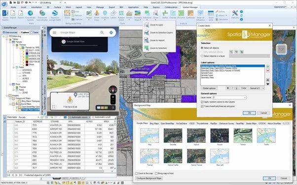
Great news! The latest version of Spatial Manager, version 9, is now available for GstarCAD 2024. This update comes packed with a host of new features and improvements that are sure to enhance your experience.

Spatial Manager for GstarCAD — a powerful plug-in to manage spatial data

Spatial Manager for GstarCAD is a lightweight and powerful GstarCAD plug-in designed for GstarCAD users to deal with spatial data in a simple, efficient and cost-effective way.

The newest version includes many new features and improvements tailored for GstarCAD users: Multi Background Maps, the practical Rubber Sheet edition, Multi Labels, User-defined Coordinate Systems, etc.

Spatial Manager 9 for GstarCAD 2024 is released

Spatial manager 9 – Key features and enhancements

Import/export spatial or GIS data into/from GstarCAD (v.2018 to v.2024), and experience the advanced tools to manage spatial data, such as dynamic Multi Background Maps, advanced Elastic edition, transform the drawing Coordinate System, quick drawing publishing in Google Earth, data structures and Data Grid, Data and Spatial Queries, Multi Labeling, Terrains, Search for locations and Geo-coding, Street View navigation, GIS Analysis and Fields CalculatorThematic Maps, etc.

Spatial Manager 9 for GstarCAD 2024 is released

Download – Spatial Manager 9 for GstarCAD

Download the latest version and explore more possibilities in the development and analysis of spatial information, planning, civil engineering, surveying, architecture, supplies, etc.

In v9 you will find the powerful enhanced Multi Background Maps, the practical Rubber Sheet edition, Multi Labels, User-defined Coordinate Systems, and many more news and enhancements that will allow you to address tasks related to spatial and territorial design and analysis like never before.


What’s new in Spatial Manager 9

New features and improvements:

·  Rubber Sheet

o    Elastic Deformation of geometries based on 2 or more Control points

o    Specify ‘Base’ and ‘Reference’ points that define the Deformation to be processed

o    The more points you enter, the more accurate the results will be

o    The order in which you select the points and the spread of the points will affect the results

o    Apply defined Deformation to the objects you select, using any selection method

·  Multiple Background / Foreground Maps

o    Show simultaneously several Image Maps in your drawing

o    Add Maps including transparent areas to be overlaid with others Maps, transparent or not

o    Manage the Maps in the of the main palette Explorer section, as can be done with Thematics

o    Activate or deactivate Image Maps, remove them, manage their overlapping positions, etc.

o    Add any kinds of Image Maps, either application-preset Maps as User-defined Maps

o    Choose whether you need only one Background Map or multiple Image Maps

·  Improved Background Maps

o    New ‘Stadia Maps’ preset group (Some previous ‘OpenStreetMap’ maps and some new ones)

o    New Maps into the ‘OpenStreetMap’ group

o    Removed the size limitation of the Background Maps window (display more Groups and/or Maps)

o    WMTS Background Maps detection has been improved

·  Raster images and Photos

o    Specific command for Importing Raster images or Photos, now also including GPS location (EXIF)

o    Export located Raster images in drawing and/or Geo-reference and Coordinate Systems files

·  Multi-Labels

o    Label objects with multiple texts (MText) including multiple lines of data

o    Include Object Data fields, CAD properties, Geometric values, etc.

o    Add, remove or sort any field or property

o    Define a global format for the Label and/or particular values (Color, Size, etc.) for each line

·  Exporting to Google Earth

o    The pin of the location point for exported Texts does not appear now, only the Labels

o    It is now possible to keep the original Texts color for the resulting exported Labels

o    Object Field Names are shown in bold characters when displaying data in Google Earth

·  Import / Export

o    It is now possible to export the Object Type in the Export processes

o    Parameters of the last Import process can be now re-used

o    Objects in Shapefiles that include Z coordinates will be imported by default as 3D Polylines

o    Images coordinate system recognition from associated PRJ files when importing

·  Selection and Zoom

o    Invert objects Selection

o    Zoom to Layer. Zoom to the objects on the selected Layers (by default on the current Layer)

o    Zoom to Selection Layers. Zoom to the objects on the Layers of selected objects

o    Zoom to Import. Zoom to the objects resulting from the last Import process

·  Coordinate Systems

o    Define and edit customized Coordinate Systems

o    The new user-defined CRSs will be added to the list of thousands preset CRSs

o    EPSG tables (CRSs and other objects) updated to version 10.096 (2023-09-30)

·  Data providers

o    New data provider for Cloud Optimized GeoTIFF / COG TIFF sources

o    Shapefile MultiPatch files supported

o    New enhanced data provider for GeoJSON files

o    GeoJSON and ASCII files Encoding can be selected when importing

o    Object Type is added as a data Field when importing GML files

o    Support for OpenStreetMap OsmChange files (.OSC)

o    Write capability (Export, etc.) for the LiDAR Data Provider (.LAS, .LAZ)

·  AutoCAD 2024, BricsCAD 24, ZWCAD 2024, GstarCAD 2024 compatible

·  … and more

Please, Download or update ‘Spatial Manager v9’ and enjoy the superb possibilities provided by this application for any user engaged in the development and analysis of spatial information, planning, civil engineering,

Download now!

Download the latest version of Spatial Manager for your GstarCAD software and boost your efficiency and workflow with the best tool for spatial data