How to import & export spatial and territorial data into/from drawings in a cheap, easy and quick way?
What is Spatial Manager?
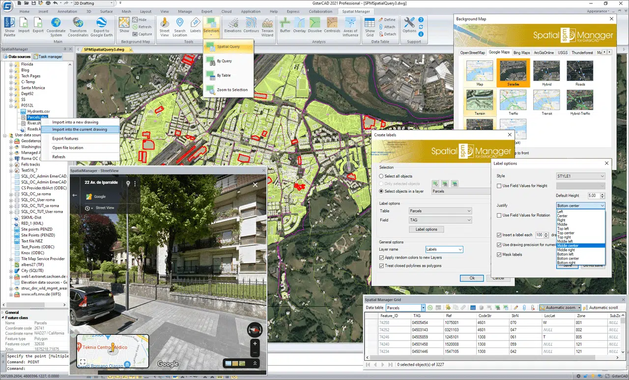
Spatial Manager™ for GstarCAD is a powerful GstarCAD plug-in designed for GstarCAD users who need to import, export, transform and manage spatial data in a simple, fast and inexpensive way, which includes many functionalities not seen so far in GstarCAD.
It comes in a lightweight application that runs inside GstarCAD and allows the user to import and export geospatial data between GstarCAD drawings and geospatial files, data servers or data stores, display background maps, manage alphanumeric data and data tables, create terrain models and contours, search for locations, transform coordinate systems, and many more geospatial functionalities.
Please note that Export functionalities are available only in Spatial Manager Professional Edition.
Why is Spatial Manager useful?
- Import into AutoCAD or GstarCADfrom Google Earth (KML or KMZ), OpenStreetMap (OSM or PBF), Shapefiles (SHP), GPS, Points (many formats), Excel, Access, ESRI ArcInfo®, MapInfo, GML (GML or GZ), PostGIS, SQL Server, SQLite, and many more geospatial sources
- Export from Autocad or GstarCAD to Google Earth (KML or KMZ), Shapefiles (SHP), Points (many formats), MapInfo, PostGIS, SQL Server, SQLite, and many more geospatial targets
- Transformation of coordinatesoptional
- Backgrounds Mapspowerful and easy to use
- Search Locations
- Terrainfunctions including 3D points from elevation services, DTM meshes, contours, etc.
- Publishing to Google Earth
- Alphanumeric datatables as AutoCAD XDATA. Manage data tables and fields. Query selection. Data viewer and editor included
- Save Tasks to replaythe import processes so many times as desired
- Interface simple,intuitive and productive
- Perpetual licenses.Pay once, no periodic fees
How to import/export spatial data?
How to import/export spatial and territorial data into/from GstarCAD drawings using a cheap, easy to use, powerful and fast tool.
From/to Google Earth KML/KMZ, OpenStreetMap, GML, GeoPackage, XML, GPS, LiDAR, Excel, Access, PostGIS, SQL, WMS, TMS, WFS Servers, Shapefiles, Raster images, Esri ASCII, Esri Geodatabase and many others data sources.
1. Export spatial data from GstarCAD
Export objects from the drawing to spatial files or databases, and saves their Extended Entity Data (EED) as alphanumeric data tables
Spatial Manager™ for GstarCAD exports objects from the drawing to spatial files or databases, and saves their Extended Entity Data (EED) as alphanumeric data tables using a wizard, which shares some of the steps with the import wizard. In the same way, the user can choose or select the export parameters to define all the target data among a great number of possibilities.
There are options to export the Coordinates, Length or Area, the objects Layer, Handle and Elevation, the Attributes and the name of the Block references and their properties, the Texts and their properties, etc. The objects will be automatically filtered when exporting, and all the geometric operations needed to fit the target data format (such as segmenting curved objects) are automatically performed
Read more about export spatial data: HERE.
2. Import spatial data into GstarCAD
Import spatial data, into new or existing GstarCAD drawings, as GstarCAD objects and Extended Entity Data (EED)
Spatial Manager™ for GstarCAD imports spatial data, into new or existing GstarCAD drawings, as GstarCAD objects and Extended Entity Data (EED), using a powerful wizard which lets the user choose or select all the necessary import parameters in order to get differentiated spatial information in a CAD drawing
Batch-import, automatic layering, fill of polygons, blocks according data values and mapped attributes, labeling, elevation, thickness or the spatial filters are only part of the application functionality when importing from spatial files, data servers, data stores, etc. (Data Providers list)
Read more about import spatial data: HERE.
In the next video you can review an example of the use of this new function in order to create a PostGIS database from different data sources (Shapefiles, KML, etc.). After exporting the tables, an import of the whole PostGIS Database generated is carried out in a drawing in order to check the results.
Spatial Manager for Free – Trial Version
Try out Spatial Manager plug-in for free, click on the Button below and install your Trial Version. Please be sure that you already have GstarCAD installed on your Computer.


